使用PostGIS完成兩點間的河流軌跡及流經長度的計算
基礎準備工作
1.PostGIS 的安裝
在安裝PostGIS前首先必須安裝PostgreSQL,然後再安裝好的Stack Builder中選擇安裝PostGIS組件。具體安裝步驟可參照 PostGIS的安裝與初步使用_不睡覺的怪叔叔的部落格-CSDN部落格_postgis
2.載入Post GIS擴展
選中指定資料庫,執行載入擴展語句
–添加支援
CREATE EXTENSION postgis;  --添加postgis擴展
CREATE EXTENSION pgrouting;   --添加pgrouting擴展
CREATE EXTENSION postgis_topology;
CREATE EXTENSION fuzzystrmatch;
CREATE EXTENSION postgis_tiger_geocoder;
在做兩點間河流軌跡及流經長度計算過程中,需要載入postgis和pgrouting兩個擴展
可以通過查看載入擴展的版本驗證擴展載入是否成功
–查看postgresql版本
show server_version;

–查看postgis版本
SELECT PostGIS_full_version();

–查看pgrouting版本
select pgr_version();
3.河流矢量圖層轉成單線格式
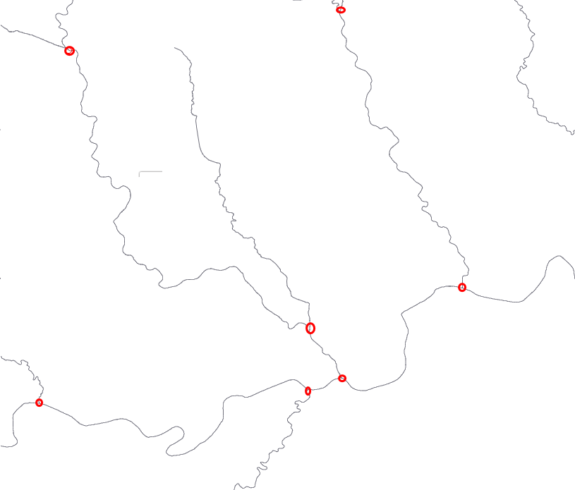
河流包括各種匯入和匯出,為了實現流經流域的計算,河流水系矢量數據需要一個河流一個ID的方式,可以在河流交匯點處將河流進行打段處理。
4.河流矢量數據導入PostgreSQL資料庫
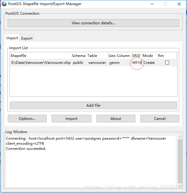
打開位於「開始>所有程式>PostGIS 2.3 bundle for PostgreSQL」之中的PostGIS Shapefile Import/Export Manager。
首先單擊"View connection details"按鈕,打開"PostGIS connection"對話框,輸入用戶名"postgres"及其對應的密碼,設置連接的資料庫,如下圖所示:

連接資料庫之後,單擊"Add file"按鈕,加入***.shp文件,並將其SRID設置為"4326",如下圖所示。這一步絕對不能省略,否則不能正確導入數據。
5.河流數據拓撲處理
在數據分析過程中,使用到了pgrouting擴展中的 pgr_dijkstra 演算法
Dijkstra演算法(迪傑斯特拉演算法),由荷蘭電腦科學家Edsger Dijkstra於1956年提出。它是一種圖搜索演算法,它解決了非負代價邊路徑圖的最短路徑問題,即從起始頂點(start_vid)到結束頂點(end_vid)的最短路徑。此演算法可以與有向圖或無向圖一起使用。
函數的簽名摘要:
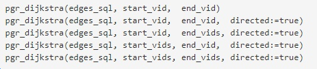
在實際使用中,需要先明確所有的頂點,並為所有頂點分配唯一的編號,函數的 start_vid 和 end_vid 都是整型數值,函數使用edges_sql參數(sql腳本)篩選出和頂點相鄰的所有邊資訊(即河流資訊)。
所以,在使用pgr_dijkstra方法前,需要
- 對找到河流的所有頂點資訊,並做唯一整型值編號
- 在資料庫中為每條河流設置好起始頂點和結束頂點
--篩選出所有頂點資訊,st_dump函數主要是將MultiLineString類型 調整成 LineString類型
select  st_astext(st_startpoint((ST_Dump(geom)).geom)) from singleriver
union
select  st_astext(st_endpoint((ST_Dump(geom)).geom)) from singleriver
將查詢結果在Excel中進行整型值編號,再導入到postgresql中的新建表 distinctpoint 中,然後關聯河流數據表,更新河流的開始頂點(source)和結束頂點編號(target)
--更新起始頂點編號
update singleriver q
set source=tt.sourcepoint
from singleriver s,
(select gid,p.id as sourcepoint from
(select gid,st_astext(st_startpoint((ST_Dump(geom)).geom)) as startpoint, st_astext(st_endpoint((ST_Dump(geom)).geom)) as endpoint from singleriver )s
left join distinctpoint p
on s.startpoint=p.point) tt
where q.gid=tt.gid
--插入結束頂點編號
update singleriver q
set target=tt.endpoint
from singleriver s,
(select gid,p.id as endpoint from
(select gid,st_astext(st_startpoint((ST_Dump(geom)).geom)) as startpoint, st_astext(st_endpoint((ST_Dump(geom)).geom)) as endpoint from singleriver )s
left join distinctpoint p
on s.endpoint=p.point) tt
where q.gid=tt.gid
至此,河流拓撲數據處理完成
PG分析處理函數
1.函數編寫
CREATE OR REPLACE FUNCTION "public"."pgr_shortest_river"(IN "startx" float8, IN "starty" float8, IN "endx" float8, IN "endy" float8, OUT "river_name" varchar, OUT "v_shpath" varchar, OUT "cost" float8)
  RETURNS SETOF "pg_catalog"."record" AS $BODY$
declare
v_startLine geometry;--離起點最近的線
v_endLine geometry;--離終點最近的線
v_startTarget integer;--距離起點最近線的終點
v_endSource integer;--距離終點最近線的起點
v_statpoint geometry;--在v_startLine上距離起點最近的點
v_endpoint geometry;--在v_endLine上距離終點最近的點
v_res geometry;--最短路徑分析結果
v_perStart float;--v_statpoint在v_res上的百分比
v_perEnd float;--v_endpoint在v_res上的百分比
v_rec record;
first_name varchar;
end_name varchar;
first_cost double precision;
end_cost double precision;
begin
--查詢離起點最近的線
execute 'select (st_dump(geom)).geom as geom,target as target,name from singleriver where
ST_DWithin(geom,ST_Geometryfromtext(''point('|| startx ||' ' || starty||')''),0.01)
order by ST_Distance(geom,ST_GeometryFromText(''point('|| startx ||' '|| starty ||')'')) limit 1'
into v_startLine ,v_startTarget,first_name;
raise notice '起點線段%',v_startLine;
raise notice '起點位置%',v_startTarget;
raise notice '河流名稱%',first_name;
--查詢離終點最近的線
execute 'select (st_dump(geom)).geom as geom,"source" as source,name from singleriver
where ST_DWithin(geom,ST_Geometryfromtext(''point('|| endx || ' ' || endy ||')''),0.01)
order by ST_Distance(geom,ST_GeometryFromText(''point('|| endx ||' ' || endy ||')'')) limit 1'
into v_endLine,v_endSource,end_name;
--如果沒找到最近的線,就返回null
if (v_startLine is null) or (v_endLine is null) then
return;
end if ;
select ST_ClosestPoint(v_startLine, ST_Geometryfromtext('point('|| startx ||' ' || starty ||')')) into v_statpoint;
select ST_ClosestPoint(v_endLine, ST_GeometryFromText('point('|| endx ||' ' || endy ||')')) into v_endpoint;

--計算距離起點最近線上的點在該線中的位置
select st_linelocatepoint(st_linemerge(v_startLine), v_statpoint) into v_perStart;

select st_linelocatepoint(st_linemerge(v_endLine), v_endpoint) into v_perEnd;

select st_distancesphere(v_statpoint,ST_PointN(ST_GeometryN(v_startLine,1), ST_NumPoints(ST_GeometryN(v_startLine,1)))) into first_cost;

select st_distancesphere(ST_PointN(ST_GeometryN(v_endLine,1),1),v_endpoint) into end_cost;

if (ST_Intersects(st_geomfromtext('point('|| startx ||' '|| starty ||') '), v_startLine) and ST_Intersects(st_geomfromtext('point('|| endx ||' '|| endy ||') '), v_startLine)) then
select st_distancesphere(v_statpoint, v_endpoint) into first_cost;

select st_linelocatepoint(st_linemerge(v_startLine), v_endpoint) into v_perEnd;
for v_rec in
select st_linesubstring(st_linemerge(v_startLine), v_perStart,v_perEnd) as point,COALESCE(end_name,'無名河流') as name,end_cost as cost loop
v_shPath:= ST_AsGeoJSON(v_rec.point);
cost:= v_rec.cost;
river_name:= v_rec.name;
return next;
end loop;
return;
end if;
--最短路徑
for v_rec in
(select st_linesubstring(st_linemerge(v_startLine),v_perStart,1) as point,COALESCE(first_name,'無名河流') as name,first_cost as cost
union all
SELECT st_linemerge(b.geom) as point,COALESCE(b.name,'無名河流') as name,st_length(geom, false) as cost
FROM pgr_dijkstra(
'SELECT gid as id, source, target, st_length(geom, false) as cost FROM singleriver
where st_intersects(geom,st_buffer(st_linefromtext(''linestring('||startx||' ' || starty ||','|| endx ||' ' || endy ||')''),0.05))',
v_startTarget, v_endSource , false
) a, singleriver b
WHERE a.edge = b.gid
union all
select st_linesubstring(st_linemerge(v_endLine),0,v_perEnd) as point,COALESCE(end_name,'無名河流') as name,end_cost as cost)
loop
v_shPath:= ST_AsGeoJSON(v_rec.point);
cost:= v_rec.cost;
river_name:= v_rec.name;
return next;
end loop;
end;
$BODY$
  LANGUAGE plpgsql VOLATILE STRICT
  COST 100
  ROWS 1000
2.參數說明
輸入參數:開始點和結束點的經緯度坐標
輸出結果:river_name:河流名稱;v_shppath:流經的河流路徑; cost:河流流經長度
3.內部調用函數說明
函數調用過程,根據postgis不同版本,函數名稱可能會有偏差,有版本展示形式為 st_linesubstring ,有版本展示形式為 st_line_substring
4.輸出結果驗證
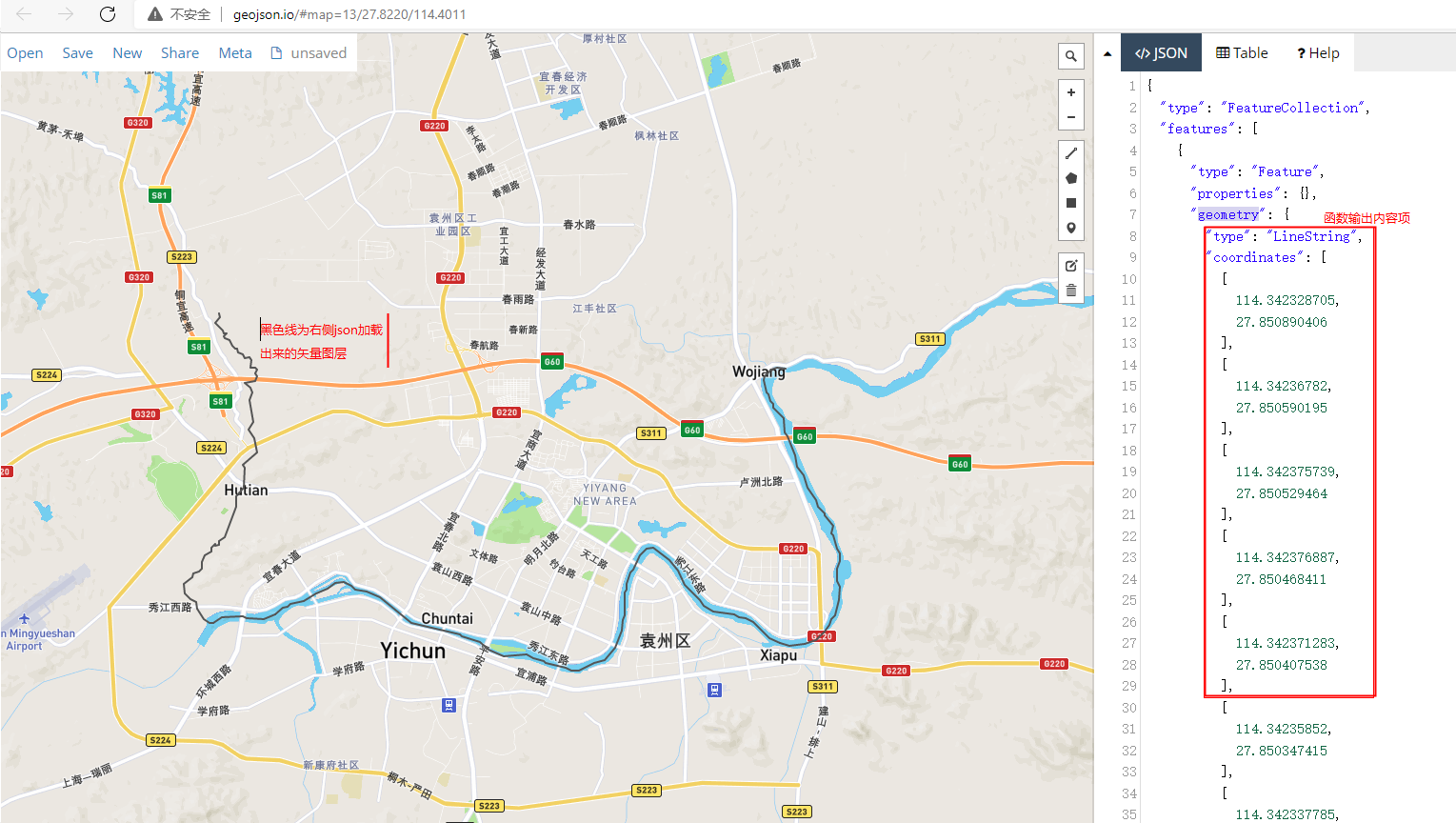
為了驗證河流輸出結果是否正確,流經河流路徑是否連通,可以通過在線geojson地圖(geojson.io)呈現出來驗證。
在右側json-features-geometry 中填充函數輸出的v_shppath參數內容(按照行單獨輸入,可以輸入多個,注意需要增加json屬性)