Day11-微信小程序实战-交友小程序-附近的人(地图的形式)及位置获取
回顾:在下面的tabbar中,我们已经实现了首页 消息 我的,就剩下”附近“页面了
”附近“的页面主要是用地图来进行展示的(可以显示我的位置,也可以显示周围附近的人的位置)
(在地图里面点击它的头像的话,就可以看到详情页了,然后也可以知道它的位置)
1、首先要利用 地图 组件-这个是小程序给我们提供的一个组件:
//developers.weixin.qq.com/miniprogram/dev/component/map.html
地图中的scale就是级别的意思,这个级别越大,在地图里面显示的就越详细了
<map id="map" longitude="113.324520" latitude="23.099994" scale="14" controls="{{controls}}" bindcontroltap="controltap" markers="{{markers}}" bindmarkertap="markertap" polyline="{{polyline}}" bindregionchange="regionchange" show-location style="width: 100%; height: 300px;"></map>
”附近“这个页面,我们在near文件里面进行操作的
最简单的实现就是,通过代码:
<!--miniprogram/pages/near/near.wxml-->
<view class="map">
  <map id="map" longitude="113.324520" latitude="23.099994" scale="14"></map>
</view>
之后通过队wxss的样式设置
/* miniprogram/pages/near/near.wxss */
.map{
  position: absolute;
  left: 0;
  top: 0;
  width: 100%;
  height: 100%;
}
.map map{
   width: 100%;
  height: 100%;
}
效果图:
之后就要变成我当前的地理位置了
那个地图属性 scale 就是详细的程度:
上面是等于14的情况,如果是==2的时候
 详细程度就更低了
2、之后就要把经纬度改成我们自己的了,就要在js文件中定义,经纬度的变量
之后还要定义一个getlocation的函数,这个函数在一开始的时候就要被调用了,也就是在onload的时候被调用了
并且下一次切换到地图的时候,可能也要再次的触发,所以在onshow里面也要执行这个函数了
3、获取用户的经纬度,微信提供了API,可以直接调用的
//developers.weixin.qq.com/miniprogram/dev/api/location/wx.getLocation.html
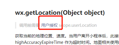
可以看到,它是想要进行授权的,我们是通过全局的app.json添加上permission来实现的
//developers.weixin.qq.com/miniprogram/dev/api/location/wx.getLocation.html
"permission": {
    "scope.userLocation": {
      "desc": "你的位置信息将用于小程序位置接口的效果展示"
    }
  }
注意在json文件里面的话不能有注释的
写好之后,就可以调用我们的getLocation函数了
wx.getLocation({
 type: 'wgs84',
 success (res) {
   const latitude = res.latitude
   const longitude = res.longitude
   const speed = res.speed
   const accuracy = res.accuracy
 }
})
上面的代码中 默认的是用 wgs84,但是在开发者文档的下面有一句话:

但是,直接用这个函数的话:
 getLocation(){
    wx.getLocation({
      type: 'gcj02',
      success(res) {
        const latitude = res.latitude
        const longitude = res.longitude
        this.setData({
          longitude,
          latitude
        });
      }
    })

  }
会报错,因为这里的this指向不对,success要用一个箭头函数才行的,设置为如下的代码才行:
 getLocation(){
    wx.getLocation({
      type: 'gcj02',
      success:(res)=> {
        const latitude = res.latitude
        const longitude = res.longitude
        this.setData({
          longitude,
          latitude
        });
      }
    })

  }
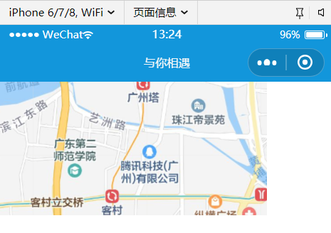
得到的效果就是,可以直接定位到我的位置了:
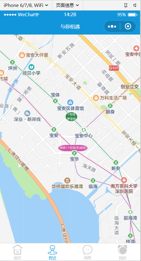
但是我们并不知道我们具体在地图上面的哪一块–其实微信也棒我们想好了,就是可以直接在map这个标签里面,添加一个 show-location 属性
<view class="map">
  <map show-location id="map" longitude="{{ longitude }}" latitude="{{ latitude }}" scale="14"></map>
</view>
效果图:
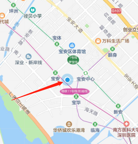
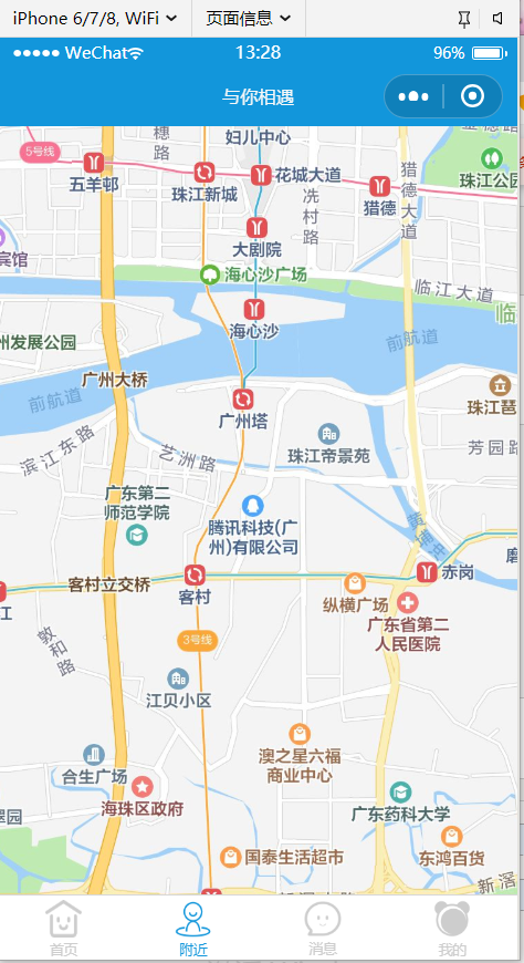
(注意:其实这个效果在真机上显示的效果会更好,可以直接扫码在真机上面进行测试的
4、获取我自己的位置之后,接下来就是,怎么获取到周围附近的人的信息呢,然后还要把用户的头像显示出来了
===这个微信也提供了,就是可以直接用map标签的属性 markers,也就是可以添加标记点,包括图片和图标这种的
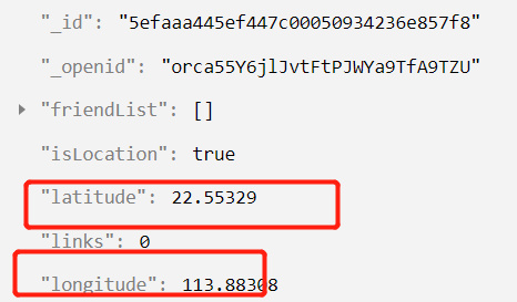
===然后因为我们是要通过用户的经纬度来获得用户的位置的,整体的逻辑,就是我们获得了用户的经纬度,和用户的头像,还有id等等信息,然后在地图中标记出来,所以users数据库中就要添加两个字段了,分别是经纬度
5、在user.js中创立数据库字段的时候,就通过:
 getLocation(){
    wx.getLocation({
      type: 'gcj02',
      success: (res) => {
        this.latitude = res.latitude
        this.longitude = res.longitude

      }
    })
  }
效果图:我们把users我的数据删掉之后,重新登陆微信,可以看到数据库页进行了更新
之后就是把这个经纬度读取出来,然后渲染到我们的地图上面即可了(然后出现了一个问题就是,我们要读取的是附近的人,如果把数据库中去用户的经纬度都读取出来,然后渲染了,这个是没有意义的,我们就是要看到哪一块,那一块的用户就显示出来这样的,就是有一个范围的
====其实小程序中给了我们这样的功能
文档-》云开发->command
//developers.weixin.qq.com/miniprogram/dev/api/location/wx.getLocation.html

并且有一个要求:
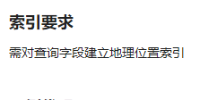
这样的索引,其实和我们在数据库中创立字段是差不多的
再次查看文档中:
//developers.weixin.qq.com/miniprogram/dev/wxcloud/reference-sdk-api/database/geo/Geo.Point.html
我们在user.js的 bindGetUserInfo(ev) 函数中,设置:
location: db.Geo.Point(this.longitude, this.latitude)
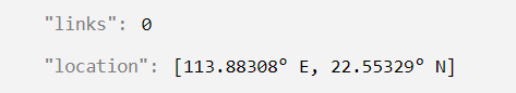
这个location设置完之后,就可以设置数据库里面的索引值了
因为在数据库添加了location这个字段,所以我们要把users里面的数据再次删除掉,之后重新的微信用户登陆,再进入数据库中
(就可以看到location:
之后就可以在数据可以中打开-》索引管理了
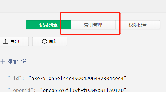
点击添加索引
命名为_location 然后设置为”非唯一“也就是不仅仅可以得到自己的,还可以得到其他用户的location,索引的字段就是我们刚刚在数据库中建立的要映射的location了,并且选择”地理位置“

(其实这个地理索引的设置 是为了 提高性能的,没有也是可以的)
再回到near.js文件中
在后面添加一个方法 getNearUsers
然后在获取了经纬度之后,就可以调用这个方法了
这个函数方法的书写,可以参考
微信文档里面的demo
const _ = db.command
db.collection('restaurants').where({
  location: _.geoNear({
    geometry: db.Geo.Point(113.323809, 23.097732),
    minDistance: 1000,
    maxDistance: 5000,
  })
}).get()
所以还要在near.js文件开头的时候 获取一下 db.command下划线
  getNearUsers(){
    db.collection('users').where({
      location: _.geoNear({
        geometry: db.Geo.Point(this.data.longitude, this.data.latitude),
        minDistance: 1000,
        maxDistance: 5000
        //这1000和5000的单位是米
      })
    });
  }
就写好了
并且还要注意一个点,我们在”个人中心“-》”编辑个人信息“里面设置了一个共享位置的打开和关闭

通过isLocation字段来设置的,就是是否开启共享位置,所以除了找到附近的人以外,还要看这个用户有没有开启”共享位置“
所以获取到的用户,既要在我们的范围以内,又要是”开启了共享位置“的
所以就还要添加一个这样的条件才可以的
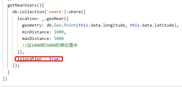
getNearUsers(){
    db.collection('users').where({
      location: _.geoNear({
        geometry: db.Geo.Point(this.data.longitude, this.data.latitude),
        minDistance: 1000,
        maxDistance: 5000
        //这1000和5000的单位是米
      }),
      islocation : true
    }).field({
      longitude : true,
      latitude : true ,
      userPhoto : true
    }).get().then((res)=>{
      console.log(res.data);
    });
  }
然后编译之后,可以看到,返回的res.data是空的
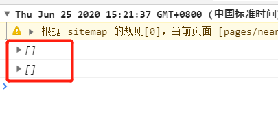
主要就是因为我们周围是没人的,才返回了空的字段了
然后我们设置的也有问题,就是1000~5000,就是距离我1000米到5000米以内的人,就不包括自己了,所以先把minDistance设置为0
看看能不能把自己打印出来咯
下面我们就来奥marker的图片标注了

要在map标签里面添加一个 markers 这样的标签了
然后还要在near.js里面给markers定义一个初始值 为一个空数组
因为在示例代码中,看到的就是数组来的
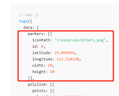
getNearUsers(){
    db.collection('users').where({
      location: _.geoNear({
        geometry: db.Geo.Point(this.data.longitude, this.data.latitude),
        minDistance: 0,
        maxDistance: 1000
        //这1000和5000的单位是米
      }),
      islocation : true
    }).field({
      longitude : true,
      latitude : true ,
      userPhoto : true
    }).get().then((res)=>{
      console.log(res.data);
      let data = res.data;
      let result = [];
      if(data.length){
        for(let i=0;i<data.length;i++){
          result.push({
            iconPath: data[i].userPhoto,
            id: data[i]._id,
            latitude: data[i].latitude,
            longitude: data[i].longitude,
            width: 30,
            height: 30
          });
        }
        this.setData({
          markers : result
        });
      }
    });
  }
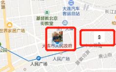
效果:
目前微信小程序还不支持把那个地图里面的图片变成是圆形的
目前是只能通过,对width和height进行矩形的渲染了
通过多账号进行一下测试:

因为测试号和我的主号都是在同一个地方的,所以我们手动的把后面的88改成是89,就可以得到效果: