ArcGIS Engine空间分析之缓冲区分析的实现
- 2019 年 11 月 5 日
- 筆記
缓冲分析(BufferAnalysis)的结果是一个面状要素——即缓冲要素,点状要素、线状要素和面状要素,被缓冲分析功能处理过之后,它们的周围产生一个缓冲区域,该区域即新产生的面状要素。
在缓冲方向上,点状要素和线状要素只能进行向外缓冲,面状要素可以双向缓冲——向外缓冲和向内缓冲。

在ArcGIS Engine中,缓冲分析由ITopologicalOperator.Buffer(double Distance)来实现,函数的返回值为IGeometry(表5-12)。其中,输入的参数为正时向外缓冲,为负时向内缓冲。
缓冲分析实现的基本思路为:
1、设置缓冲距离
2、调用ITopologicalOperator.Buffer()方法生成缓冲区
3、向axMapControl中添加缓冲区。
// // 摘要: // Constructs a polygon that is the locus of points at a distance less than or equal // to a specified distance from this geometry. // 构造一个多边形,该多边形是距离此几何体小于或等于指定距离的点的轨迹。 IGeometry Buffer(double distance);
(1)Buffer方法的参数
Bulfer方法仅携带了唯一的一个参数:distance,它用以设置缓冲的距离。输入的数字为正时向外缓冲;为负时向内缓冲(仅面状对象)。
(2)Buffer功能的基本思路
Buffer方法并没有产生新的要素类(Feature Class),因为Buffer方法的返回值为lGeometry,仅为要素的几何形状,不携带任何要素属性特征。
所以说,在ArcGIS Engine中,Buffer方法并不能直接产生一个缓冲结果的要素对象。
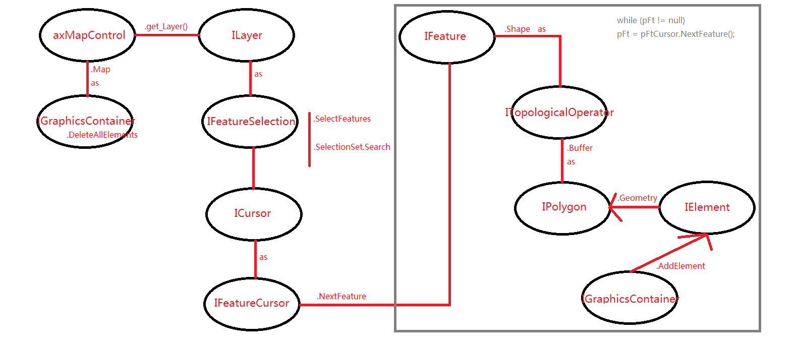
显示了触发Bufer按钮事件,如图所示:

缓冲区分析函数:BufferArea(double BuffDistance)
/// <summary> /// 缓冲区分析函数 /// </summary> /// <param name="BuffDistance">缓冲区距离</param> private void BufferArea(double BuffDistance) { //以主地图为缓冲区添加对象 IGraphicsContainer graphicsContainer = axMapControl1.Map as IGraphicsContainer; //删除之前存留的所有元素 graphicsContainer.DeleteAllElements(); //选中索引值为0的图层 ILayer layer = axMapControl1.get_Layer(0); //此循环用于查找图层名为LayerName的图层索引 /* ILayer layer = null; for (int i = 0; i < axMapControl1.LayerCount; i++) { if (axMapControl1.get_Layer(i).Name.Equals("Layer-Name")) { layer = axMapControl1.get_Layer(i); break; } } */ //将图层名为LayerName的图层强转成要素选择集 IFeatureSelection pFtSel = (IFeatureLayer)layer as IFeatureSelection; //将图层名为LayerName的图层中的所有要素加入选择集 pFtSel.SelectFeatures(null, esriSelectionResultEnum.esriSelectionResultNew, false); ICursor pCursor; //获得遍历选择集中所有要素的游标 pFtSel.SelectionSet.Search(null, false, out pCursor); IFeatureCursor pFtCursor = pCursor as IFeatureCursor; IFeature pFt = pFtCursor.NextFeature(); //遍历所有选择集中的所有要素, 逐个要素地创建缓冲区 while (pFt != null) { //将要素的几何对象(pFt.Shape)强转成ITopologicalOperator //pFt.Shape即为创建缓冲区的操作对象 ITopologicalOperator topologicalOperator = pFt.Shape as ITopologicalOperator; //注意: BuffDIstance输入为正时向外缓冲, 为负时向内缓冲 IPolygon polygon = topologicalOperator.Buffer(BuffDistance) as IPolygon; //实例化要素以装载缓冲区 IElement element = new PolygonElement(); //将几何要素赋值为多边形 element.Geometry = polygon; //逐个显示 graphicsContainer.AddElement(element, 0); //指向下一个 pFt = pFtCursor.NextFeature(); } //这里清除选择集, 以免高亮显示的要素与缓冲结果相互混淆 pFtSel.Clear(); //刷新axMapControl1 axMapControl1.Refresh(); }
核心缓冲分析函数总结:
谢谢观看!本人初学GIS二次开发,如果有不对的地方,请多多包涵!