ArcGIS Engine简单图形绘制功能的实现(点、线、面)
- 2019 年 10 月 28 日
- 筆記
我们添加点、线、面来实现图形的编辑需要使用Geometry对象类。

Point(点)
是一个0维的几何图形,具有X、Y坐标值,以及可选的属性,如高程值(Z值)、度量值(M值)、ID值等,可用于描述需要精确定位的对象。
Polyline(线)
是一个有序路径(Path)的集合,这些路径既可以是连续的,也可以是离散的。折线可用于表示具有线状特征的对象,用户可以用单路径构成的折线来表示简单线,也可以用具有多个路径的多义线来表示复杂线类型。
Polygon(面)
是环(Ring)的集合,环是一种封闭的路径。Polygon可以由一个或者多个环组成,甚至环内嵌套环。但是内、外环之间不能重叠,它通常用来描述面状特征的要素。

操作步骤大纲:
①定义一个Operation枚举
②设置鼠标移动的函数
③添加图形绘制的单击事件
④axMapContol控件的鼠标单击事件
⑤完善各事件中需要用到的函数
①定义一个Operation枚举
//定义一个Operation枚举 enum Operation { ConstructionPoint,//绘制点 ConstructionPolyLine,//绘制线 ConstructionPolygon,//绘制面 Nothing }
②设置鼠标移动的函数
/// <summary> /// 鼠标移动的函数 /// </summary> /// <param name="sender"></param> /// <param name="e"></param> private void axMapControl1_OnMouseMove(object sender, IMapControlEvents2_OnMouseMoveEvent e) { try { toolStripStatusLabel1.Text = string.Format("{0},{1} {2}", e.mapX.ToString("#######.##"), e.mapY.ToString("#######.##"), axMapControl1.MapUnits.ToString().Substring(4)); } catch { } }
③添加图形绘制的单击事件
#region 添加图形绘制的单击事件 private void 点ToolStripMenuItem_Click(object sender, EventArgs e) { oprFlag = Operation.ConstructionPoint; } private void 折线ToolStripMenuItem_Click(object sender, EventArgs e) { oprFlag = Operation.ConstructionPolyLine; geoCollection = new PolylineClass(); ptCollection = new PolylineClass(); } private void 面ToolStripMenuItem_Click(object sender, EventArgs e) { oprFlag = Operation.ConstructionPolygon; } #endregion
④axMapContol控件的鼠标单击事件
/// <summary> /// axMapContol控件的鼠标单击事件 /// </summary> /// <param name="sender"></param> /// <param name="e"></param> private void axMapControl1_OnMouseDown(object sender, IMapControlEvents2_OnMouseDownEvent e) { //表示 System.Type 信息中的缺少值。 此字段为只读。 missing = Type.Missing; //若为添加点的事件 if (oprFlag == Operation.ConstructionPoint) { //axMapControl1控件的当前地图工具为空 axMapControl1.CurrentTool = null; //通过AddPointByStore函数, 获取绘制点的图层——Cities //从GetPoint函数获取点的坐标 AddPointByStore("Cities", GetPoint(e.mapX, e.mapY) as IPoint); //点添加完之后结束编辑状态 oprFlag = Operation.Nothing; } //若为添加折线的事件 if (oprFlag == Operation.ConstructionPolyLine) { //axMapControl1控件的当前地图工具为空 axMapControl1.CurrentTool = null; //获取鼠标单击的坐标 //ref参数能够将一个变量带入一个方法中进行改变, 改变完成后, 再将改变后的值带出方法 //ref参数要求在方法外必须为其赋值, 而方法内可以不赋值 ptCollection.AddPoint(GetPoint(e.mapX, e.mapY), ref missing, ref missing); //定义集合类型绘制折线的方法 pGeometry = axMapControl1.TrackLine(); //通过addFeature函数的两个参数, Highways——绘制折线的图层; Geometry——绘制的几何折线 AddFeature("Highways", pGeometry); //折线添加完之后结束编辑状态 oprFlag = Operation.Nothing; } //若为添加面的事件 if (oprFlag == Operation.ConstructionPolygon) { //axMapControl1控件的当前地图工具为空 axMapControl1.CurrentTool = null; // CreateDrawPolygon(axMapControl1.ActiveView, "Counties"); //面添加完之后结束编辑状态 oprFlag = Operation.Nothing; } }
⑤完善各事件中需要用到的函数
1、添加点的事件中需要用到的函数:
AddPointByStore
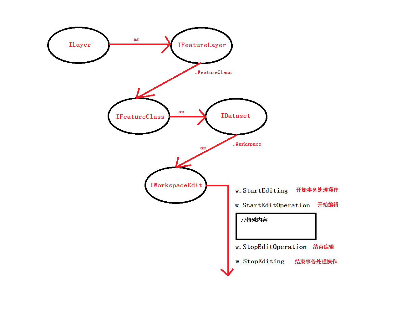
/// <summary> /// 获取绘制点的图层——Cities, 保存点绘制的函数 /// </summary> /// <param name="pointLayerName"></param> /// <param name="point"></param> private void AddPointByStore(string pointLayerName, IPoint pt) { //得到要添加地物的图层 IFeatureLayer pFeatureLayer = GetLayerByName(pointLayerName) as IFeatureLayer; if (pFeatureLayer != null) { //定义一个地物类, 把要编辑的图层转化为定义的地物类 IFeatureClass pFeatureClass = pFeatureLayer.FeatureClass; //先定义一个编辑的工作空间, 然后将其转化为数据集, 最后转化为编辑工作空间 IWorkspaceEdit w = (pFeatureClass as IDataset).Workspace as IWorkspaceEdit; IFeature pFeature; //开始事务操作 w.StartEditing(false); //开始编辑 w.StartEditOperation(); //创建一个(点)要素 pFeature = pFeatureClass.CreateFeature(); //赋值该要素的Shape属性 pFeature.Shape = pt; //保存要素, 完成点要素生成 //此时生成的点要素只要集合特征(shape/Geometry), 无普通属性 pFeature.Store(); //结束编辑 w.StopEditOperation(); //结束事务操作 w.StopEditing(true); } //屏幕刷新 this.axMapControl1.ActiveView.PartialRefresh(esriViewDrawPhase.esriViewGeography, pFeatureLayer, null); }
2、添加线事件中需要用到的函数(也包含面面事件)
GetPoint
/// <summary> /// 获取鼠标单击时的坐标位置信息 /// </summary> /// <param name="x"></param> /// <param name="y"></param> /// <returns></returns> private IPoint GetPoint(double x, double y) { IPoint pt = new PointClass(); pt.PutCoords(x, y); return pt; }
添加实体对象到地图图层(添加线、面要素) AddFeature
/// <summary> /// 添加实体对象到地图图层(添加线、面要素) /// </summary> /// <param name="layerName">图层名称</param> /// <param name="pGeometry">绘制形状(线、面)</param> private void AddFeature(string layerName, IGeometry pGeometry) { ILayer pLayer = GetLayerByName(layerName); //得到要添加地物的图层 IFeatureLayer pFeatureLayer = pLayer as IFeatureLayer; if (pFeatureLayer != null) { //定义一个地物类, 把要编辑的图层转化为定义的地物类 IFeatureClass pFeatureClass = pFeatureLayer.FeatureClass; //先定义一个编辑的工作空间, 然后将其转化为数据集, 最后转化为编辑工作空间 IWorkspaceEdit w = (pFeatureClass as IDataset).Workspace as IWorkspaceEdit; IFeature pFeature; //开始事务操作 w.StartEditing(true); //开始编辑 w.StartEditOperation(); //在内存创建一个用于暂时存放编辑数据的要素(FeatureBuffer) IFeatureBuffer pFeatureBuffer = pFeatureClass.CreateFeatureBuffer(); //定义游标 IFeatureCursor pFtCursor; //查找到最后一条记录, 游标指向该记录后再进行插入操作 pFtCursor = pFeatureClass.Search(null, true); pFeature = pFtCursor.NextFeature(); //开始插入新的实体对象(插入对象要使用Insert游标) pFtCursor = pFeatureClass.Insert(true); try { //向缓存游标的Shape属性赋值 pFeatureBuffer.Shape = pGeometry; } catch (COMException ex) { MessageBox.Show("绘制的几何图形超出了边界!"); return; } //判断:几何图形是否为多边形 if (pGeometry.GeometryType.ToString() == "esriGeometryPolygon") { int index = pFeatureBuffer.Fields.FindField("STATE_NAME"); pFeatureBuffer.set_Value(index, "California"); } object featureOID = pFtCursor.InsertFeature(pFeatureBuffer); //保存实体 pFtCursor.Flush(); //结束编辑 w.StopEditOperation(); //结束事务操作 w.StopEditing(true); //释放游标 Marshal.ReleaseComObject(pFtCursor); axMapControl1.ActiveView.PartialRefresh(esriViewDrawPhase.esriViewGeography, pLayer, null); } else { MessageBox.Show("未发现" + layerName + "图层"); } }
3、添加面事件中需要用到的函数
CreateDrawPolygon
/// <summary> /// 添加面事件 /// </summary> /// <param name="activeView"></param> /// <param name="v"></param> private void CreateDrawPolygon(IActiveView activeView, string sLayer) { //绘制多边形事件 pGeometry = axMapControl1.TrackPolygon(); //通过AddFeature函数的两个参数, sLayer——绘制折线的图层; pGeometry——绘制几何的图层 AddFeature(sLayer, pGeometry); }
注:AddFeature函数在上面已经提及,调用即可
核心AddFeature函数总结:
谢谢观看!本人初学GIS二次开发,如果有不对的地方,请多多包涵!